Maps. They help us make sense, of where we are, where we are going, and — maybe not enough — where we have been. We use the things most days.
How often do you open up a map app on your mobile phone to help you? Where is somewhere? Maybe furthermore: What is the route there? How can I can get there? How long could it take? Maybe because we use maps in various ways. Sometimes we’re just curious what is around us, what is around somewhere. What are the closest cinemas? Where can I get a coffee near where I am going? What motorway services are on the trip we are taking? What is the name of that river than runs through York? Where was that bridge we walked over last weekend?
I remember as a child so many times being on the back seat of my parents’ car with only an A to Z of Great Britain for company. As we drove along the roads I tried to work out where we were, sometimes my finger tracing our route if there were landmarks we passed, road turnings usually.
I started to look beyond what was just along the roads we traveled, looking further afield (usually literally looking beyond the field I could see from the car). The river Trent flows into the Humber I learnt. If it wasn’t for the Humber Bridge driving from Grimsby to Hull would take a lot longer time. Skegness is after Mablethorpe if you go down the coast. The Wash I just found fascinating. I really could go on here.
I started to look up and learn about places in other parts of the country, understanding where things and places were. Stonehenge I learnt about at school. Where is that? If the index at the back of the road atlas didn’t it’d mean finding the large double pages where I thought it was and scanning, scouring the maps.
Not everything was physical. We went to stay in Chepstow, and on the way in the atlas I could see rivers and bridges I didn’t know about before, seeing the England/Wales border wind up the river Wye. Standing near Tintern Abbey I could see the river. The border is a boundary we can only see fully on a map, but then the river makes it clearly visible in the world as we experience it.
On that same trip I learned about the contour lines on maps, how they showed hills. Lines but showing something different from human boundaries of ownership.
The layers of maps, eh.
I’ve used a lot of mapping techniques and made a lot of maps in my work over the years: As a designer to a business director, on products, services, organisations, businesses. (Here is one from the chlamydia discovery work I was involved with on NHS.UK.)
Often in design work people seem to revert to the hierarchy of mapping. We’ll start with some form of storyboarding. We’ll then map experiences. We’ll then map journeys. We will do it in that order. It’s as if this is The Process.
I say ‘often’. I think this is too often.
Take a second and think about this: What is your problem?
We know nothing.
I know nothing.
They know nothing.
We all seem to come at this from different angles. How can we all find a common view?
How does this bit we are looking at fit in along other bits?
We see too much.
How things are. How things could be. How things were. Movement between those even, how the landscape shifts over time.
Take your problem and think what do you want the map to do?
Worry less about types of map, the type of map you are doing, what order you are doing it. Worry less full stop. Just make a start. Get down what you know and what you want to find out. See if you can find those things out and update the map. Whatever shape it is in take a step back.
Environments are living things. So, maps should be living things. What they are right now might not be what they are in the future. Things change. The landscape. Our understanding. Maps are living things. And our approaches to mapping and what we are mapping should be equally adapting.
Whenever I join anything I scribble down notes, I look for relationships — links, patterns — between things, I map things out.
With any service work I start and do I want to understand what is the service? and what is the service as the team understands it?. Mapping helps. I just start by scribbling things down. If I have to go back through it all at some point and reorder and reshape it, that’s absolutely fine!
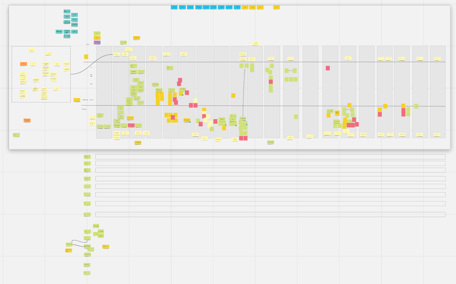
When I joined NHS Jobs I started to create a service map. What type was it? It was just drawing together understanding. Does the type really matter? It was like a big virtual wall where I dumped everything. I changed the shape of it several times and it grew. Some pockets are in vast detail compared to others. Some areas are clearer than others. Some clearer areas are because nothing happens there, some clearer areas are gaps in my knowledge — and in the team’s knowledge. It helped me understand the idea of what is the service and what the team viewed the service they were working on (not mutually the same things).
A few months ago there was enough detail and shape this service map was useful for some of the team I was on.
But it wasn’t an especially useful tool for the wider team. They needed something zoomed in, they wanted the equivalent of the large spreads of the road atlas I used to pour over. But they also only wanted certain elements highlighted, like when use a map app on your phone. I want to see cycle paths only you might choose.
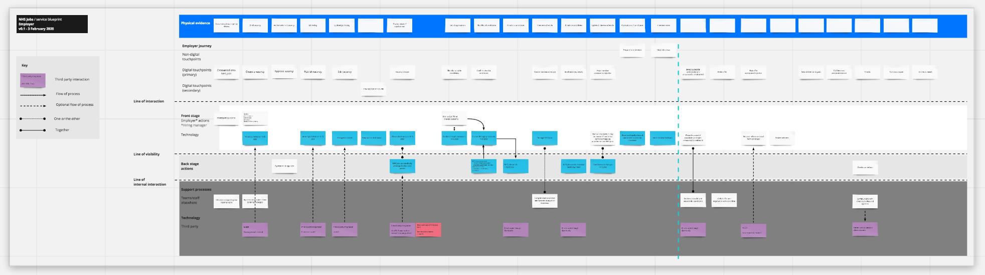
The team wanted to see how someone in a particular role would go through the digital side of the service, and show when supporting systems and processes might come into play. We need to show only certain layers of the map. There was the problem.
As we started to pull elements out into their own map it became clear a service blueprint format would meet the problem’s needs. But we only got to that from taking the problem and what the map should do.
Remember: Take your problem and think What do you want the map to do?.
This post tagged with:
maps